Showing posts with label Hartsop. Show all posts

Monday, 27 August 2012

Deer, Mist, Chocolate Brownies & Custard


There is a real sense of camaraderie in a large walking group and I really enjoyed the Great Gable walk in July.  The second Twitter walk I went on (arranged once again by the social butterfly Gina) was made up of 15 people and two dogs (Hollie and Lassie) and a large supply of Gina’s legendary chocolate brownies.  We started from the tiny hamlet of Hartsop, which means “Valley of the Deer” (which I have written about before) and as I pulled into the car-park at 8.15 there was already a small crowd gathering for the walk.  The crowd got larger and at one point an individual looking for some solitude in the early morning arrived in the car-park and was shocked that it was virtually full and there was a crowd of people chatting and laughing in the corner!  

Hayeswater Gill
The mist was hanging in the valley casting eerie shadows all around.  My first thought as we set off was that if there were 15 people then surely I would not be the slowest this time!  Hurrah!  I started off at the front with Gina as we marched along the path towards Hayeswater and we were making great progress.  Then we hit a steep section and I dropped back to the middle of the group.  At the gate at the top of the steep bit I took the opportunity for a “view stop” and found myself at the back of the group again.  Situation normal!  Alan and Phil kept me company and it was the first time I had met Alan so it was nice chatting all the way to Hayeswater and admiring the Gill. 

Hayeswater Dam
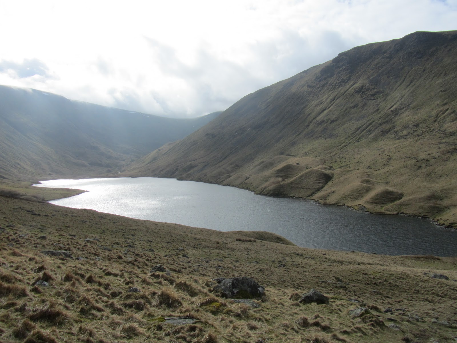
Hayeswater is a reservoir and is surrounded by moraines (little hilly mounds left by glaciers in the last ice age as they retreated) and it looked really mysterious with the mist surrounding it and the fells above peering out of the cloud.  

Hayeswater (Moraines on the right)
Our first fell was The Knott and we started making our way up the grassy ascent (various comments were passed about the fact that “Fix the Fells” needed to add this to their list of paths to repair as it was not in very good shape – I made a mental note!)  As the slope flattened out, I was in the group at the back and we took a view stop (which by then had become known as “Tanya stops”...which I will not comment on) and as we chatted, we saw in the distance through the mist a group of beautiful red deer gathered on the fell side swathed in sunshine.  It was a beautiful sight and the first time I have seen deer on the fells.  At last!  It was really magical watching them as they stood in majesty and looked back at us.  There are advantages to being slow and we called to the group ahead of us to point them out.  We were all mesmerised. 

Red Deer
The Knott summit was only a short climb from there and Dave took on the role of waiting for me.  From the summit we had our first high level glimpse of Hayeswater even though there was still mist around and to the surrounding fells.  Our next stop was Rampsgill Head so off we set again.  The route started on a good path and it was only a stroll but to get to the summit we had to leave the path and head over the grass and marsh.  My “Fix the Fells” instinct emerged then as I could not stop the words “fan out!” escaping my lips to minimise our impact on the landscape.  Fortunately everyone tolerates my obsession (although jokes about building cairns are frequent!)

We had all fallen into group chatting and were all following each other so when we arrived at a cairn, no one was quite certain whether we were actually on the summit.  After we had looked at about three maps and three phone apps, I got out my Garmin GPS (which tells you exactly where you are and is essential walking equipment for me) and confirmed this was indeed the summit.  Hurrah!  The third fell was a short walk to High Raise and then fell four was Kidsty Pike.  Neither involved too much exertion and we all kept chatting and enjoying the day.  

On the summit of High Street - Eating Chocolate Brownies!
Chocolate Brownie & Custard
The main event for the day was High Street and we were hopeful that by the time we arrived the sun would have emerged.  Such optimists!  Off we set and after a while I saw the group in the front stop at a cairn.  “Is that the summit?”  I asked hopefully.  No – sadly not.  Just a cairn on the path.  So I took a deep breath and carried on up the slope.  It was wet and boggy so I found the going quite tiring.  It fell to Ray to wait for me but eventually we made it to the summit (still misty) and the prize for arriving – chocolate brownies!  Yippee!  Better still Gary and Alan had brought hot custard in flasks so with plastic bowls and spoons passed around, all 15 of us sat on the summit of High Street eating chocolate brownies and custard!  We must have been a sight to behold and I think this is probably a first for the Lake District fells (although I believe they have apple pie and custard on Everest so I think it is a trend that could be set).  If word keeps spreading of Gina’s chocolate brownie walks then we all agreed we would need a helicopter drop to bring everything up!

I left the walk at this point as my mission later in the day was to take a friend’s family to Blackmoss Pot, a plunge pool in the Langstrath Valley in Borrowdale.  So I headed back down around The Knott and to Hayeswater.  I was a little late so I decided to attempt a spot of fell-running.  After all, the path was good and there was no one around.  This was a mistake.  I started off well but I am not a natural runner (I seem to have too many legs and arms) and after a few minutes (which I was impressed I managed) I tripped over a rock and fell forwards.  After a quick check to make sure no one had seen, I picked myself up, brushed down my dignity and reverted to walking.  Much safer!

Blackmoss Pot
A couple of hours later I was walking the path to Blackmoss Pot with three adults, two children and Tully the Lurcher.  The sun had come out and the valley was beautiful.  Blackmoss Pot is a natural deep plunge pool on the Langstrath Beck.  It is surrounded by rocks and in the middle of the valley.  If you did not know it was there you could easily miss it.  I was the first in (wearing trousers and a t-shirt as it was so cold) sliding gracefully (well almost gracefully) into the pool and was followed quickly by the children.  I got out swiftly after a minute or two to find the warm sunshine!  The children were braver than me – wearing swimming costumes and jumping in!  It was really cold though so our swim did not last long and then we got changed and made our way back along the valley.

Tully
Ten miles on the group walk in the morning (thanks Gina for arranging it and Ray for planning the route) and a further five miles in the afternoon.  A great day ending with having dinner cooked for me and a large glass of prosecco.  Perfect.
Follow Heelwalker1 on Twitter

Sunday, 29 July 2012

A Lake, Cave & Tumble


Brothers Water
I have been fascinated to see photos of a cave on the slopes of Dove Crag called the “Priests’ Hole” as the photos from inside show extensive views across mountains and valleys beyond and the cave itself looks eerie.  It is marked on Ordnance Survey maps and I was determined to go and see if for myself. 

Cascade on Dovedale Beck
After consulting an expert I had my route planned, starting at the small lake called Brothers Water near the village of Hartsop.  Brothers Water used to be called Broad Water but the name was changed in the 19th century when two brothers tragically drowned there.  The sister of the famous Lakeland poet William Wordsworth, Dorothy Wordsworth (a poet in her own right) referred to it as a “glittering, lively lake” and that is just how it looked as I walked along the path beside it with tree branches hanging over.

Taking time to admire the flora (view stop)
The walk up the valley towards Dove Crag was beautiful with the rippling streams and many cascades of Dovedale Beck and the imposing crags getting closer.  It was a lovely place to be that day.  The gentle incline after a couple of miles turned into a steep final ascent to the cave however!  From a distance, it did not look like a route was possible up the scree slope but fortunately an old stone-pitched path was still in existence and whilst it did not lessen the gradient, it did make for easier climbing.  The path to the cave is off from the main path and an erratic boulder marks the spot to turn off and you can see the mouth of the cave from there.  A short scramble later and I had arrived at the cave.

"Priest's Hole" Cave
Looking from the Jaws of the Cave
It was just as striking as I had imagined with the dark jaws of the cave leading to views down the valley and across the fells that were every bit as lovely as I had hoped.  Even though it was a bit cloudy, it was mesmerising.  Having mastered the timer on my camera, I even managed to include myself in one of the photos.  The cave is natural but a stone wall has been constructed over part of the front for additional shelter.  There was evidence of camping activity inside such as candles and some matting but it was all neatly stacked and someone had also left a book for people visiting the cave to sign – I signed on the very back page as the rest of it was full.  Mission accomplished!

However, I decided to continue the walk onto Dove Crag summit and as I could not see a clear route from where I was, I dropped back down to the main path near the boulder.  After Dove Crag I headed to Hart Crag which was only a short distance away.  Both these fells are part of the Fairfield Horseshoe and I had not been on them since the “Mystery of the Rucksack” incident back in February!  The sun even started to emerge as I sat on Hart Crag having lunch and whilst it was cold for July, it was a great day for walking.  I headed off over the fell Hartsop Above How.  This is not one of the most frequented fells in the Lake District but the ridge route over the top is gentle and there are excellent views of the surrounding crags and valleys and down into Hartsop.

View Down the Valley
The final part of my route took me off the side of Hartsop above How to return to the shores of Brothers Water on a grassy path.  This was the most straightforward part of the walk.  Or so I thought.  However, I lost the path.  The map and GPS said there was a right of way where I was but there was certainly no path – just a lot of bracken!  I could just about see another path further down the slope so putting thoughts of bugs and snakes to one side, I decided to head through the thick bracken to the path.  This was a mistake as when I took my first step, I tripped over a rock I had not seen and fell forward in what was actually a rather graceful roly poly movement and ended up a few feet further down my route than originally intended with bracken in my hair and sitting in a little muddy stream.  I sat there for a few minutes wondering what on earth had happened (but secretly impressed that I can still do a roly poly) and then managed to get up, brush myself down and join the actual path with a flick of the hair.  So much for glamorous walking!

Brothers Water & Surrounding Fells
The short walk to the car-park from there was uneventful (I am pleased to say) and after changing out of my rather wet and muddy trousers and removing the final traces of bracken from my hair, I headed off to Glenridding for a well-deserved drink.  A great walk but next time I will attempt to do it without the roly poly!
Hartsop

Follow Heelwalker1 on Twitter

Tuesday, 17 January 2012

The Valley of the Deer


deer photo
A beautiful deer (photo not taken by me sadly!**)
“Hart” in Old English translates as “deer” and the word “sop” means valley, therefore the small hamlet of Hartsop in the Lake District means the “valley of the deer”.*  Amongst the more famous fells behind Hartsop that include High Street, Thornthwaite Crag and The Knott, is one called The Nab which is part of the Martindale Deer Forest and one I have been looking forward to climbing as I think deer are some of the most beautiful animals in the world.  I am lucky enough to live near a deer park on the Kent/Sussex border and sometimes they escape into the garden – to see a deer on a frosty moonlit evening or moving in the shadows like a ghost on a misty morning is enchanting and romantic.  

Hayeswater - with moraines at the edge
I climbed The Nab in March 2011 but began the route with The Knott and Rest Dodd.  I parked at the car-park in Hartsop on a cold but beautiful sunny day with only a few high clouds in the sky.  I began the route on the path at the foot of Gray Crag and followed it up towards Hayeswater Reservoir.  The path is quite gentle the whole way to the Reservoir and follows close to Hayeswater Gill.  Hayeswater is a natural lake used as a Reservoir for Penrith and it is 425 metres or 1,400 feet above sea-level.  The lake water was very still and clear with several people fishing there and I crossed over the dam to start the steeper ascent of The Knott.  Around the edge of Hayeswater were dozens of moraines from the last Ice Age when melting glaciers left deposits of soil and debris (that is the extent of my recollection of moraines from my GCSE Geography days....I had an excellent teacher but it was many years ago now!  He also taught me how to map read, a skill which has been developed much more fully over the years than my knowledge of glaciers!)
Rest Dodd & The Knott from Gray Crag
The steep grassy path to the ridge of The Knott was tiring but the final quarter of the climb was on a better path with views opening out increasingly to the High Street range behind.  It was quite a busy day for walkers but there was no one else heading up to The Knott – they all seemed to be heading to High Street, which is a shame as the summit of The Knott was only a few hundred feet up from the main path and had lovely views across to Gray Crag, Thornthwaite Crag, High Street and towards the next fell on the route, Rest Dodd.  

Rest Dodd & The Nab
As I got back down to dip (technical term) between The Knott and Rest Dodd, a group of students appeared on the ridge.  They had come up the same way as me from Hayeswater but were slightly less enthusiastic about the whole idea than I had been.  Their teacher (I assume) was doing his very best to inspire them about the geology, history and beauty of the area but they really looked stoically uninterested and exhausted.  As I walked passed them to towards Rest Dodd, I heard one of them say “who on earth would do this for fun?”  Me it would seem...but as I was about to say that, I remembered my A-level Geography trip to the Blencathra Centre (yes, so enthused was I by glaciers at GCSE I continued the subject to A-Level).  There were about 15 of us and on our first day we climbed Blencathra in the rain, wind and cloud with not a view to be seen and my opinion of fell-climbing at that point was much the same as this group.  Funny how much I have changed!

Peat Bogs on The Nab
The route to Rest Dodd was straightforward – simply a case of following the wall between the two summits.  Rest Dodd is not the most interesting summit in the Lakes but the views were excellent, particularly to The Nab, which was the fell I was most excited about climbing.  The view to The Nab from Rest Dodd showed interesting soil patterns which I had a dreadful feeling meant bogs!  A steep descent from Rest Dodd to the ridge of The Nab showed me I was right – the whole route across the top was a series of peat bogs and difficult crossings which turned into a major problem-solving exercise to try and get across each one without having to step in the bogs.  It could easily have made a game show of some description.  Now hard though you may find this to believe, I was actually very good at it and did not once fall into the bogs!  Such progress!   I was expecting some kind of award once I had completed it but sadly there was no one to witness my lightness and deftness of foot (yet there is always someone there to witness it when I am less elegant and fall in...fate has an awful sense of humour)!  

As well as watching where I was putting my feet, I kept a watchful eye out for any deer that may be on the fell.  The red deer herd in Martindale Deer Forest is the oldest native herd of deer in England and the onus is on walkers to ensure they do not disturb them and stick to the recommended paths.  Whilst the views on the walk were lovely, I was extremely disappointed not to see any deer on the fell.  When I climbed Troutbeck Tongue in September however, I saw a beautiful deer with stunning antlers wander into view and stand and gaze out across the valley.  I did not have time to take a photo before it wandered off but it is a sight I will never forget – he stood with such majesty, as though he were master of all he surveyed.  They are such elegant and beautiful animals.
Angle Tarn
I did not want to have to retrace my steps from The Nab back up Rest Dodd and to continue on in the direction I was walking would have taken me off the preferred path but also into a valley too far away from Hartsop.  So I decided to be creative and once I got back to the wall between The Nab and Rest Dodd, followed it in the direction of Brock Crags in the hope I would find the path in that direction that would take me back down into Hartsop via Angle Tarn.  I cannot pretend it was an easy route or that I was on a path most of the time (I made the mistake of following a couple who looked like they knew where they were going – I am not sure how you can “look like” you know where you are going but they were very convincing...sadly, whilst they probably did know where they were going, it was a different way to the way I wanted!!  It is a basic error in fell-walking to assume anyone knows where they are going or if they do, that it is the same way you want to go....I know this well and would never follow a random motorist with the same objective if I were in a car but the fells can do strange things to even experienced walkers sometimes!)  With the magic of GPS, I did eventually find the path and was very glad I did as Angle Tarn looked beautiful.  I had climbed Brock Crags and Angletarn Pikes (a very distinctive part of the Ullswater scenery) a couple of years before but had forgotten how lovely Angle Tarn is.  It is an eerie tarn with an island in the middle as though it had been sculpted in a perfect mountain setting.

Ullswater and Boredale Hause from the Angletarn Path
The route back took me down to Boredale Hause and a sharp left took me back through a woody area and a clear track to Hartsop.  Although I did not see any deer that day, I was still captured by the history and magic of the area, saw some lovely views and had a well-deserved hot chocolate at the Kirkstone inn on the summit of the Kirkstone Pass.

To prove how much I love deer, I have a painting by a local Kent artist on my wall at home.
Painting by a local Kent artist


*"Making sense of place names of the Lake District" - David Watson
** From Google Images

Follow Heelwalker1 on Twitter