 |
| A beautiful deer (photo not taken by me sadly!**) |
“Hart” in Old English translates as “deer” and the word “sop” means valley, therefore the small hamlet of Hartsop in the Lake District means the “valley of the deer”.* Amongst the more famous fells behind Hartsop that include High Street, Thornthwaite Crag and The Knott, is one called The Nab which is part of the Martindale Deer Forest and one I have been looking forward to climbing as I think deer are some of the most beautiful animals in the world. I am lucky enough to live near a deer park on the Kent/Sussex border and sometimes they escape into the garden – to see a deer on a frosty moonlit evening or moving in the shadows like a ghost on a misty morning is enchanting and romantic.
 |
| Hayeswater - with moraines at the edge |
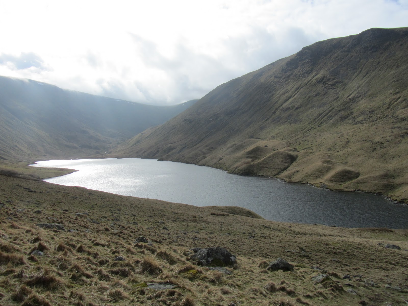
I climbed The Nab in March 2011 but began the route with The Knott and Rest Dodd. I parked at the car-park in Hartsop on a cold but beautiful sunny day with only a few high clouds in the sky. I began the route on the path at the foot of Gray Crag and followed it up towards Hayeswater Reservoir. The path is quite gentle the whole way to the Reservoir and follows close to Hayeswater Gill. Hayeswater is a natural lake used as a Reservoir for Penrith and it is 425 metres or 1,400 feet above sea-level. The lake water was very still and clear with several people fishing there and I crossed over the dam to start the steeper ascent of The Knott. Around the edge of Hayeswater were dozens of moraines from the last Ice Age when melting glaciers left deposits of soil and debris (that is the extent of my recollection of moraines from my GCSE Geography days....I had an excellent teacher but it was many years ago now! He also taught me how to map read, a skill which has been developed much more fully over the years than my knowledge of glaciers!)
 |
| Rest Dodd & The Knott from Gray Crag |
The steep grassy path to the ridge of The Knott was tiring but the final quarter of the climb was on a better path with views opening out increasingly to the High Street range behind. It was quite a busy day for walkers but there was no one else heading up to The Knott – they all seemed to be heading to High Street, which is a shame as the summit of The Knott was only a few hundred feet up from the main path and had lovely views across to Gray Crag, Thornthwaite Crag, High Street and towards the next fell on the route, Rest Dodd.
 |
| Rest Dodd & The Nab |
As I got back down to dip (technical term) between The Knott and Rest Dodd, a group of students appeared on the ridge. They had come up the same way as me from Hayeswater but were slightly less enthusiastic about the whole idea than I had been. Their teacher (I assume) was doing his very best to inspire them about the geology, history and beauty of the area but they really looked stoically uninterested and exhausted. As I walked passed them to towards Rest Dodd, I heard one of them say “who on earth would do this for fun?” Me it would seem...but as I was about to say that, I remembered my A-level Geography trip to the Blencathra Centre (yes, so enthused was I by glaciers at GCSE I continued the subject to A-Level). There were about 15 of us and on our first day we climbed Blencathra in the rain, wind and cloud with not a view to be seen and my opinion of fell-climbing at that point was much the same as this group. Funny how much I have changed!
 |
| Peat Bogs on The Nab |
The route to Rest Dodd was straightforward – simply a case of following the wall between the two summits. Rest Dodd is not the most interesting summit in the Lakes but the views were excellent, particularly to The Nab, which was the fell I was most excited about climbing. The view to The Nab from Rest Dodd showed interesting soil patterns which I had a dreadful feeling meant bogs! A steep descent from Rest Dodd to the ridge of The Nab showed me I was right – the whole route across the top was a series of peat bogs and difficult crossings which turned into a major problem-solving exercise to try and get across each one without having to step in the bogs. It could easily have made a game show of some description. Now hard though you may find this to believe, I was actually very good at it and did not once fall into the bogs! Such progress! I was expecting some kind of award once I had completed it but sadly there was no one to witness my lightness and deftness of foot (yet there is always someone there to witness it when I am less elegant and fall in...fate has an awful sense of humour)!
As well as watching where I was putting my feet, I kept a watchful eye out for any deer that may be on the fell. The red deer herd in Martindale Deer Forest is the oldest native herd of deer in England and the onus is on walkers to ensure they do not disturb them and stick to the recommended paths. Whilst the views on the walk were lovely, I was extremely disappointed not to see any deer on the fell. When I climbed Troutbeck Tongue in September however, I saw a beautiful deer with stunning antlers wander into view and stand and gaze out across the valley. I did not have time to take a photo before it wandered off but it is a sight I will never forget – he stood with such majesty, as though he were master of all he surveyed. They are such elegant and beautiful animals.
 |
| Angle Tarn |
I did not want to have to retrace my steps from The Nab back up Rest Dodd and to continue on in the direction I was walking would have taken me off the preferred path but also into a valley too far away from Hartsop. So I decided to be creative and once I got back to the wall between The Nab and Rest Dodd, followed it in the direction of Brock Crags in the hope I would find the path in that direction that would take me back down into Hartsop via Angle Tarn. I cannot pretend it was an easy route or that I was on a path most of the time (I made the mistake of following a couple who looked like they knew where they were going – I am not sure how you can “look like” you know where you are going but they were very convincing...sadly, whilst they probably did know where they were going, it was a different way to the way I wanted!! It is a basic error in fell-walking to assume anyone knows where they are going or if they do, that it is the same way you want to go....I know this well and would never follow a random motorist with the same objective if I were in a car but the fells can do strange things to even experienced walkers sometimes!) With the magic of GPS, I did eventually find the path and was very glad I did as Angle Tarn looked beautiful. I had climbed Brock Crags and Angletarn Pikes (a very distinctive part of the Ullswater scenery) a couple of years before but had forgotten how lovely Angle Tarn is. It is an eerie tarn with an island in the middle as though it had been sculpted in a perfect mountain setting.
 |
| Ullswater and Boredale Hause from the Angletarn Path |
The route back took me down to Boredale Hause and a sharp left took me back through a woody area and a clear track to Hartsop. Although I did not see any deer that day, I was still captured by the history and magic of the area, saw some lovely views and had a well-deserved hot chocolate at the Kirkstone inn on the summit of the Kirkstone Pass.
To prove how much I love deer, I have a painting by a local Kent artist on my wall at home.
 |
| Painting by a local Kent artist |
*"Making sense of place names of the Lake District" - David Watson
** From Google Images

Great read! Impressed you missed the bogs! We did the Hayeswater to The Knott route at high speed in the failing light and mist on the day we got lost on Racecourse Hill... We saw the deer in the mist though, but it was too dark to take a pic.
ReplyDeleteThanks Beth - I will go back again to try and see the deer. I remember seeing a photo from (I think) the early 1900's of people and horses up on Racecourse Hill...amazing!
ReplyDeleteGreat post. I love all the detail you put in about place names and routes.
ReplyDeleteThanks Paul! I find the background to place names in the Lakes fascinating. Actually I find the whole Lake District fascinating...
ReplyDeletePity you didn't spot any deer Tanya. I saw some only yesterday below Brock Crag. I find early morning is the best time for sightings but being wild they soon disappear once they get wind of you. Well done negotiating those peat bogs.
ReplyDeleteLove the idea of dodging peat bogs as a game show. Now who would be the MC?
ReplyDeleteAnd funny that you were once a reluctant climber like those students.
Loved the pix too.
Hi Maggie - I will go back early morning to spot the deer next time then. Hope I am as lucky with the bogs a second time!
ReplyDeleteHi Chloe - I think someone who is a lover of heels would make a good peat-bog-dodging host!
Good one Tanya! Etymology was part of my degree for a time and I remember a fantastic map we produced for Lakeland as a department based on field study and research we had made. Such studies can help plot migration and identify areas where things might have been slower to change, such as valley heads where later invaders had to occupy. Not all the Vikings were thugs and displaced the indigenous population as history might want us to believe! I often wonder what happened to that map and whether it's been deposited somewhere in the library or archive at Lancaster. Anyway, the rest of your blog is also excellent. It is such discussion that makes the fabric of such description a whole lot more interesting. I have been raising this very point with many people recently. Too many walk descriptions are poor, "Turn left here, turn right there, go over bridge and get bored here!" WELL DONE AGAIN! P.S. I once swerved to miss deer near Elterwater. The Landy lost traction on ice, bounced off a wall on the offside and consequently caused £2500 of damage! Of course the deer skipped off probably without a thought. My man at the garage? He said, "Dear deer!!"
ReplyDeleteThank you Peter :) Having read the book mentioned in the blog I have become fascinated by the meanings of words and places in the Lakes.
ReplyDeleteI would be interested in seeing your map if you ever track it down... I visited the Hardknott Fort on the Pass in the autumn and imagining how they coped with the climate and walking/marching on the fells is amazing and I want to learn more about the history of the area (I gave up Geography for University and focused on History!)
Thanks for your very kind comments on my blog style - I love writing about the Lakes and hope others find at least parts of it interesting!
As for the car - I see that happen a lot near where I live...but awful joke from the garage guy!!
Interesting little route.. Can't wait to try it....Thanks
ReplyDeleteThanks Jimmy - hope you see some deer if you do!
ReplyDeleteA most entertaining read with some familiar elements: following, or being followed by, other walkers. I guess it's true in all popular walking areas but none more so than the Lakes!. We've been followed many times, particularly in thick mist, by people assuming that a) we are going where they want to go and b) wherever that is, there must be a clear path (surely nobody would walk anywhere without an easy path?). Eee dear!.
ReplyDeleteWalkers have actually followed us down the wrong side of a mountain and we later had to tell them they were in the wrong valley.
The deer are very skittish and incredibly well camouflaged, you can sometimes be looking directly at a whole herd some distance away and not see them until they move.
Thanks Geoff! I am a seasoned walker and should have known better than to follow others but it is not the first and probably will not be the last time I go into 'sheep' mode!
ReplyDeleteI am looking forward to seeing the deer next time - I expect they were put off by my bog-dodging antics (although I am surprised they did not sell tickets!) :)
Tanya,
ReplyDeleteSo glad you're all right. ;D I miss deer. We had so many in Ohio. Here in Florida we have a smaller species, but being in the city, I never see them.
Bless you for sharing your wonderful journey with us.
Have a beautiful evening. ;)
~ Aithne
Thanks Aithne - deer are so beautiful and I aspire to take an amazing photo of them somewhere in the Lake District at some point! In the meantime it is nice seeing them in the garden from time to time...especially this time of the year with the frost.
ReplyDeleteThank you for commenting and have a wonderful evening as well.
Tanya :) x
What a wonderful description of a marvellous area. My wife and I drove across from the Eden Valley (the Cumbrian one, not Kent!) along Ullswater to Glenridding and Hartsop only last weekend. That was mainly a car drive, not a walk, but I was looking up at the mountains and wondering where to go next time. I think you've helped me decide.
ReplyDeleteThanks David :)
DeleteI hope you see the deer if you do this route. Early morning is the best time apparently. I am going to try it again in the summer to try and get some photos of them.
I was on the Kent Eden Valley path last weekend near Hever castle...slightly more convenient!
Tanya
Hello again, since first reading this blog post I have visited this area on three separate occasions (www.artsy72.blogspot.com) and so the fells you describe mean a lot more to me now. It is a beautiful area of the lakes. I'm still to bag The Nab and Angle Tarn Pikes but I might venture elsewhere for a while. You write very well. Keep blogging
ReplyDeleteHi Paul - thanks for the compliment :)
ReplyDeleteGlad you are enjoying the Lakes...I cannot wait to go back there again...a few weeks time hopefully!
Tanya