Monday, 23 January 2012

Seven Sisters and a Lighthouse


Beachy Head Lighthouse - Keep the Stripes!
Sussex has a beautiful coastline, with the Seven Sisters and Beachy Head cliffs being a famous part of it – where the hills of the South Downs meet the sea.  An iconic landmark here is the lighthouse at Beachy Head with its distinctive white and red stripes, built in the sea in 1902.  The white and red lighthouse was built to replace the cliff-top lighthouse called Old Belle Tout, which was built in 1832 and has been moved more than once owing to coastal erosion.  The stripes on the Beachy Head lighthouse are under threat at the moment owing to the cost of maintaining them but there is a “Keep the Stripes” campaign that was launched in October 2011 and is doing a fantastic job to raise money and gain support.  I hope it will succeed as the lighthouse is so distinctive and it would be a real shame to let such a striking part of the history of the area fade to grey.  Keep the stripes!

Cliffs & Beach from Birling Gap
My walk of the Seven Sisters began at Birling Gap in the National Trust car-park.  The coastline at Birling Gap is notorious for shipwrecks and since 1563 at least 25 ships have been wrecked between there and Cuckmere Haven (the other end of the Seven Sisters) due to the fast moving currents.  Birling Gap was also notorious for smuggling as the quiet coves on the shore made an excellent place for landing boats filled with contraband from the continent.  The goods would then be transported at night to local villages and ultimately onto London for sale.  Smuggling in the area began in the 1300’s but was at its peak in the 1600’s and 1700’s, particularly focusing on tea, wine, spirits and tobacco.

Now on this walk I did not have a map as it is a straightforward route and I had done it before.  However, I did find it rather tricky finding the path from the car-park.  The route to Beachy Head was obvious but I wanted to head in the opposite direction.  There was a track that signposted a range of Bed and Breakfasts but I could not see a sign saying it was the footpath as well.  So – what does any girl do in such a situation?  I rang my Mum to ask her which way I needed to go!  My Mum is as good as any Satellite Navigation or Ordnance Survey map.  Mum confirmed the route was up the track so off I went, noticing how perilously close the houses are to the cliff edge!  The views must be outstanding though.
The Seven Sisters from Seaford Head
Brave Sheep on the Cliff Edge
The Seven Sisters were formed by geological activity 50-100 million years ago and they are effectively seven hills between Birling Gap and Cuckmere Haven.  The “dips” in between were formed by ancient rivers no longer in evidence.  It was an extremely windy day and as I got to the top of the second hill, I was battling so hard against the wind that it felt like I was not getting anywhere – each step forward was a few inches and progress was slow!  I needed a lot of view stops but each time, I was rewarded with excellent views along the coast in both directions.  Even the seagulls were absent from the cliffs owing to the wind.  I did however see some incredibly brave sheep grazing right at the edge of the cliff – one sheep in particular was grazing on a section that looked extremely precarious as there was an enormous crack in the rock that looked like a fault-line and could come crashing down into the sea at any moment.  It just goes to show that southern sheep can be just as tough and brave as the hardy Herdwicks in the Lake District!  I also saw a lot of people surfing – much braver than me...it must have been freezing in the water in January!

Sarsen Stone with Seaford Head beyond
Cuckmere Haven & Seaford Head
The Seven Sisters path is within the newly formed South Downs National Park and is part of the South Downs Way (which is 160km in total, ending at Beachy Head which is 535 feet above sea level and from which Timothy Dalton parachuted from a Jeep in the James Bond film “The Living Daylights”).  Each “sister” has a name - Haven Brow, Short Brow, Rough Brow, Brass point, Flagstaff Point, Flat Hill, Baily’s Hill and Went Hill Brow.  On top of Flagstaff Point is a Sarsen Stone (sandstone) monument and this is a helpful landmark on the route so you know which hill you are on!  I think I miscounted the hills as when I got to the top of what I thought was number seven, it turned out to be number six.  I would have been more upbeat about that but the true number seven looked the steepest of the lot!  Once I got to the top of the final Sister however I was rewarded with superb views into Cuckmere Haven with Seaford Head beyond and the sweeping meanders of the River Cuckmere in the estuary on its final few hundred metres to the sea.  The contrast between the lazy Cuckmere River and the waves dashing the cliffs below was quite something. 
Seven Sisters with Old Belle Tout Lighthouse Beyond
On the way back (yes I did 14 hills rather than seven as I had to get back to the car), it was much easier as the wind pretty much swept me up the hills!  It was enormous fun (although important not to get too close to the cliff edge!) and for good measure, I climbed up to Beachy Head to see the lighthouse.  On a clear day, you can see for miles along the coast and inland from the top of Beachy Head but that was not to be on that day sadly.  I have been there before however when the sky is bright blue without a cloud in sight and the contrast between that and the white cliffs from the chalk Downs is simply mesmerising.  The red and white lighthouse is a key part of that view – long may it remain!
Iconic Lighthouse & Beachy Head

Tuesday, 17 January 2012

The Valley of the Deer


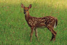
deer photo
A beautiful deer (photo not taken by me sadly!**)
“Hart” in Old English translates as “deer” and the word “sop” means valley, therefore the small hamlet of Hartsop in the Lake District means the “valley of the deer”.*  Amongst the more famous fells behind Hartsop that include High Street, Thornthwaite Crag and The Knott, is one called The Nab which is part of the Martindale Deer Forest and one I have been looking forward to climbing as I think deer are some of the most beautiful animals in the world.  I am lucky enough to live near a deer park on the Kent/Sussex border and sometimes they escape into the garden – to see a deer on a frosty moonlit evening or moving in the shadows like a ghost on a misty morning is enchanting and romantic.  
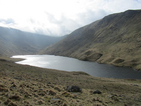
Hayeswater - with moraines at the edge
I climbed The Nab in March 2011 but began the route with The Knott and Rest Dodd.  I parked at the car-park in Hartsop on a cold but beautiful sunny day with only a few high clouds in the sky.  I began the route on the path at the foot of Gray Crag and followed it up towards Hayeswater Reservoir.  The path is quite gentle the whole way to the Reservoir and follows close to Hayeswater Gill.  Hayeswater is a natural lake used as a Reservoir for Penrith and it is 425 metres or 1,400 feet above sea-level.  The lake water was very still and clear with several people fishing there and I crossed over the dam to start the steeper ascent of The Knott.  Around the edge of Hayeswater were dozens of moraines from the last Ice Age when melting glaciers left deposits of soil and debris (that is the extent of my recollection of moraines from my GCSE Geography days....I had an excellent teacher but it was many years ago now!  He also taught me how to map read, a skill which has been developed much more fully over the years than my knowledge of glaciers!)
Rest Dodd & The Knott from Gray Crag
The steep grassy path to the ridge of The Knott was tiring but the final quarter of the climb was on a better path with views opening out increasingly to the High Street range behind.  It was quite a busy day for walkers but there was no one else heading up to The Knott – they all seemed to be heading to High Street, which is a shame as the summit of The Knott was only a few hundred feet up from the main path and had lovely views across to Gray Crag, Thornthwaite Crag, High Street and towards the next fell on the route, Rest Dodd.  

Rest Dodd & The Nab
As I got back down to dip (technical term) between The Knott and Rest Dodd, a group of students appeared on the ridge.  They had come up the same way as me from Hayeswater but were slightly less enthusiastic about the whole idea than I had been.  Their teacher (I assume) was doing his very best to inspire them about the geology, history and beauty of the area but they really looked stoically uninterested and exhausted.  As I walked passed them to towards Rest Dodd, I heard one of them say “who on earth would do this for fun?”  Me it would seem...but as I was about to say that, I remembered my A-level Geography trip to the Blencathra Centre (yes, so enthused was I by glaciers at GCSE I continued the subject to A-Level).  There were about 15 of us and on our first day we climbed Blencathra in the rain, wind and cloud with not a view to be seen and my opinion of fell-climbing at that point was much the same as this group.  Funny how much I have changed!

Peat Bogs on The Nab
The route to Rest Dodd was straightforward – simply a case of following the wall between the two summits.  Rest Dodd is not the most interesting summit in the Lakes but the views were excellent, particularly to The Nab, which was the fell I was most excited about climbing.  The view to The Nab from Rest Dodd showed interesting soil patterns which I had a dreadful feeling meant bogs!  A steep descent from Rest Dodd to the ridge of The Nab showed me I was right – the whole route across the top was a series of peat bogs and difficult crossings which turned into a major problem-solving exercise to try and get across each one without having to step in the bogs.  It could easily have made a game show of some description.  Now hard though you may find this to believe, I was actually very good at it and did not once fall into the bogs!  Such progress!   I was expecting some kind of award once I had completed it but sadly there was no one to witness my lightness and deftness of foot (yet there is always someone there to witness it when I am less elegant and fall in...fate has an awful sense of humour)!  

As well as watching where I was putting my feet, I kept a watchful eye out for any deer that may be on the fell.  The red deer herd in Martindale Deer Forest is the oldest native herd of deer in England and the onus is on walkers to ensure they do not disturb them and stick to the recommended paths.  Whilst the views on the walk were lovely, I was extremely disappointed not to see any deer on the fell.  When I climbed Troutbeck Tongue in September however, I saw a beautiful deer with stunning antlers wander into view and stand and gaze out across the valley.  I did not have time to take a photo before it wandered off but it is a sight I will never forget – he stood with such majesty, as though he were master of all he surveyed.  They are such elegant and beautiful animals.
Angle Tarn
I did not want to have to retrace my steps from The Nab back up Rest Dodd and to continue on in the direction I was walking would have taken me off the preferred path but also into a valley too far away from Hartsop.  So I decided to be creative and once I got back to the wall between The Nab and Rest Dodd, followed it in the direction of Brock Crags in the hope I would find the path in that direction that would take me back down into Hartsop via Angle Tarn.  I cannot pretend it was an easy route or that I was on a path most of the time (I made the mistake of following a couple who looked like they knew where they were going – I am not sure how you can “look like” you know where you are going but they were very convincing...sadly, whilst they probably did know where they were going, it was a different way to the way I wanted!!  It is a basic error in fell-walking to assume anyone knows where they are going or if they do, that it is the same way you want to go....I know this well and would never follow a random motorist with the same objective if I were in a car but the fells can do strange things to even experienced walkers sometimes!)  With the magic of GPS, I did eventually find the path and was very glad I did as Angle Tarn looked beautiful.  I had climbed Brock Crags and Angletarn Pikes (a very distinctive part of the Ullswater scenery) a couple of years before but had forgotten how lovely Angle Tarn is.  It is an eerie tarn with an island in the middle as though it had been sculpted in a perfect mountain setting.

Ullswater and Boredale Hause from the Angletarn Path
The route back took me down to Boredale Hause and a sharp left took me back through a woody area and a clear track to Hartsop.  Although I did not see any deer that day, I was still captured by the history and magic of the area, saw some lovely views and had a well-deserved hot chocolate at the Kirkstone inn on the summit of the Kirkstone Pass.

To prove how much I love deer, I have a painting by a local Kent artist on my wall at home.
Painting by a local Kent artist


*"Making sense of place names of the Lake District" - David Watson
** From Google Images

Tuesday, 10 January 2012

Bewl Water & Rupert Bear


Low water levels at Bewl Water
The Kent/Sussex area has some beautiful landscapes and walks and one of the walks I enjoy the most is around Bewl Water (not to be confused with Bluewater the shopping centre, although I am partial to a long walk around there as well!)  Bewl Water is a reservoir on the Kent/Sussex border created between 1973 and 1978 by building a 900 metre long and 30 metre high dam.  The perimeter of the reservoir is 17 miles, making it the largest inland water area in the south east.  The official walk around Bewl Water however is less at 13 miles.  It has over recent years become an excellent centre for watersports, fishing, biking, conservation and what are termed “adrenaline activities”.... The mind boggles!  I confess however I did lead a team a few years ago to build a raft out of wood, empty plastic cans and rope that we then had to take out on Bewl Water to make sure it floated.  Only a few of us were brave enough to try it. I am relieved to say it did float, despite the best efforts of the rest of the team (who were not brave enough to get on it) trying to sink it from a motor boat!  Happy days!

Sailing boats near the Visitor Centre
The day of the walk was cold and a bit cloudy but dry and the views for the whole walk were excellent (the advantage sometimes of low-level walks).  I started from a small lane on a bridge over the Reservoir and headed off towards the visitor centre, about two miles away.  As you can see from the photos, the water levels were really low for the time of year, which does not bode well for the summer months.  The Reservoir is usually fed from the River Teise at Goudhurst and the River Medway at Yalding during winter months.  Despite being low however, there was still a lot of activity on the water with canoes and sailing boats and the memories of the raft I was on came flooding back!
Crossing the bridge over a cascade

The water tower and dam
The walk takes you over the dam, which is superb with the water tower right next to it, so you get a view of the main part of the Reservoir.  The overall shape of the reservoir is rather odd, particularly when it is low with lots of inlets.  As I went through the gate to get onto the dam, I noticed a sign on it that said “Bewl Water round the lake walk 13 miles”.  This was a shock to me....I had cycled the route back in the summer but it has been a while since I walked it and in my head, thought it was about 10 miles.  To find out it was 13 was a bit disheartening as the difference between 10 and 13 miles for me is tired legs!  But onwards towards the Visitor Centre I went.  There was not a lot of activity at the Centre itself at this time of year but there still seemed to be a lot of boats going on and off the water.
View from the dam
Path through the woods at the edge of Bewl Water
Once past the centre, the walk follows the ins and outs of the Reservoir for a few miles.  The trick here is to keep an eye out for cyclists as the route is shared between walkers/runners, horses and cyclists.  It seems to work well though.  This part of the walk is my favourite – there is nothing tricky about it, with clear paths, beautiful woods and extensive views across the Weald and the Reservoir and the gradients are easy.  The Weald of Kent and Sussex were partly the inspiration behind the Rupert the Bear stories and drawings by Mary Tourtel, who lived in Canterbury.  It is thought Nutwood (Rupert Bear's home) was set it the Sussex Weald.  The character was then continued by Alfred Bestall who created the famous annuals.
Rupert Bear & Badger
About a third of the walk is on the road and away from the Reservoir.  Whilst it seems a long way, it is all on very small country lanes with hardly any traffic and with some excellent views back towards the reservoir, including a flock of Canadian Geese at one point!  It also means you can make progress quickly on this part.  There are some lovely cottages and houses around and about and you really get to see a lot of oast houses, which are a unique part of the Kent and Sussex landscape.  

Canadian Geese from the road
When back towards Bewl Water, if there has been rain it can be quite muddy so take care!  Whilst I managed to stay upright, (with a few acrobatics) I did see someone else walking the other way who did not appear to be so fortunate and on occasion for me it was touch and go!  There are no bogs however, which is a relief to me otherwise I definitely would have been less fortunate.  

I have to say the final two miles were extremely tiring as I had kept up a fair pace but when the car came into sight, it was not a time to be optimistic as there was still another large inlet to negotiate and probably another mile to walk.  It felt rather like getting to what you think is the top of a mountain, only to find where you are there that the true top is another 100 feet climb away!  It is a challenging 13 miles, despite being mainly flat but the views are superb in that part of the county and it is well worth the effort.

I will write about Bluewater another time!
The final part of the walk